
Title
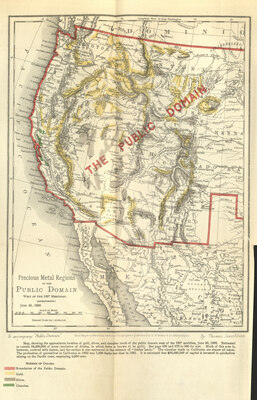
Precious Metals Regions of the Public Domain West of the 100 Meridian (Approximate) June 30, 1883
Preview
Johnson's Bibliographic Reference
1883-61
Creation Date
1883
Description
To accompany "Public Domain" by Thomas Donaldson
Map showing the approximate location of gold, silver, and cinnabar lands of the public domain west of the 100 meridian, June 30, 1883. Estimated to contain 64,000,000 acres (exclusive of Alaska, in which there is known to be gold). Much of this area is however, covered with timber, and the surface is also embraced in the estimate of "timber Lands." The cinnabar lands in California are almost all taken. The production of quicksilver in California in 1882 was 7,000 flasks less than in 1881. It is estimated that $30,000,000 of capital is invested in quicksilver mining on the Pacific coast, employing 5,000 men.